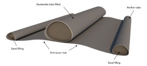
It is a geosystem dedicated to marine applications. It consists of two geotextile envelopes. The outer envelope is a woven geotextile and the inner one is nonwoven, with filter openings to be adapted according to the nature of the filling sand.
Once the anti-scour mat is in place, it is possible to start laying the tubes. These are laid in pairs for the purpose of staggered positioning.
The installation is carried out using the Traso-1 pontoon equipped with a GPS satellite guidance tool (DGPS), as before, for the laying of mats.
The divers, after having positioned the tube, begin the assembly of the pumping connections on the four geoports to fill the tube with sand.
On the bridge of the pontoon, a system of valves and T allows the tilting of pumps from one geoport to another and regulation of the flow of sand into the tubes.
The filling time of a 30 metre tube is estimated at between ten and twelve hours. The height adjustment of the device is done by operating the valves or the total shutdown of one of the pumps.
During the filling, the divers check the fitness of the device and unlock the attachments as required according to progress. Once the geotextile tube is filled, the divers disconnect the geoports and block them with blank taps.
The operations are thus repeated in the same way for the second tube laid in parallel. For its positioning, it is bound to its twin.